I'm an administrator and need to install and configure Application Manager
Take a look at the following to install and set up Application Manager and your other Rizing Geospatial applications in a flash.
Installation Requirements
Please review and familiarize yourself with the following requirements below prior to installation.
Review the Application Architecture requirements and recommendations.
Requirements:
- .NET 4.7.2 (or higher)
- Windows Server 2012 (or higher)
- Internet Information Services 8.5 (or higher)
- Modern web browser
- Chrome
- Firefox
- Safari
- Edge
- IE 11+
| No ESRI | ESRI Software | |||||||
| Products | An LRS | Database Connection | ArcGIS Server | Roads & Highways | ESRI Geodatabase | ArcGIS Desktop | Rizing Software | |
| Web | HPMS Assistant | Required | Required | Optional | Optional | Optional | TDS, SA, VA | |
| Job Execution Manager | Optional | Optional | Optional | |||||
| MAVRIC | Optional | Optional | Optional | TDS | ||||
| Report Engine | Required | TDS | ||||||
| Road Analyzer | Required | Required | Optional | Optional | TDS, RE (for printing) | |||
| Road Video Viewer | Required | TDS | ||||||
| Segment Analyzer | Required | Required | Optional | Optional | Optional | TDS | ||
| Validation Assistant | Optional | Required | Optional | Optional | Optional | TDS | ||
| Desktop | Intersection Manager | Required | Required | Optional | Required | |||
Note: Depending on what products you will be installing, and running, a map service may be required to be published through ArcGIS Server and accessible from applications to consume data through the map service – see “Data Sources” for more information on configuring the map service URL.
| Web | Desktop | ||||||
| ArcGIS Version | Road Analyzer | Segment Analyzer | Validation Assistant | HPMS Assistant | Report Engine | Road Video Viewer | Intersection Manager |
| Pro 2.8 | Supported | Supported | Supported | Supported | Supported | Supported | TBD |
| Pro 2.9 | Supported | Supported | Supported | Supported | Supported | Supported | TBD |
| Pro 3.0 | Supported | Supported | Supported | Supported | Supported | Supported | TBD |
| Enterprise 10.9 | Supported | Supported | Supported | Supported | Supported | Supported | TBD |
| Enterprise 10.9.1 | Supported | Supported | Supported | Supported | Supported | Supported | TBD |
| Enterprise 11.0 | Supported | Supported | Supported | Supported | Supported | Supported | TBD |
| Enterprise 11.1 | Supported | Supported | Supported | Supported | Supported | Supported | TBD |
| Compatible | The product is no longer fully supported against this version, but is likely still compatible. Rizing Geospatial does not offer any guarantee of compatibility. | ||||||
| Supported | The product is tested and fully functional. Product modifications will be made if an incompatibility is discovered. | ||||||
| Not Supported | The product is not compatible. | ||||||
| *Not Supported | The product is under development and may become compatible in the future. | ||||||
| **Not Supported | The product is not compatible due to an ESRI defect that was fixed in a later version. | ||||||
Note: You can not publish a map service from desktop to ArcGIS Enterprise past 10.8.1.
| Web | Desktop | ||||||
| Version | Road Analyzer | Segment Analyzer | Validation Assistant | HPMS Assistant | Report Engine | Road Video Viewer | Intersection Manager |
| ArcGIS 10.2 | Compatible | Compatible | Compatible | Compatible | Compatible | Compatible | Not Supported |
| ArcGIS 10.2.1 | Compatible | Compatible | Compatible | Compatible | Compatible | Compatible | Not Supported |
| ArcGIS 10.3 | Compatible | Compatible | Compatible | Compatible | Compatible | Compatible | Compatible |
| ArcGIS 10.3.1 | Compatible | Compatible | Compatible | Compatible | Compatible | Compatible | Compatible |
| ArcGIS 10.4 | Compatible | Compatible | Compatible | Compatible | Compatible | Compatible | Compatible |
| ArcGIS 10.4.1 | Supported | Supported | Supported | Supported | Supported | Supported | Supported |
| ArcGIS 10.5.0 | Compatible | Compatible | Compatible | Compatible | Compatible | Compatible | **Not Supported |
| ArcGIS 10.5.1 | Supported | Supported | Supported | Supported | Supported | Supported | Supported |
| ArcGIS 10.6.0 | Supported | Supported | Supported | Supported | Supported | Supported | Supported |
| ArcGIS 10.6.1 | Supported | Supported | Supported | Supported | Supported | Supported | Supported |
| ArcGIS 10.7.1 | Supported | Supported | Supported | Supported | Supported | Supported | Supported |
| ArcGIS 10.8.1 | Supported | Supported | Supported | Supported | Supported | Supported | Supported |
| ArcGIS 11.1 | Supported | Supported | Supported | Supported | Supported | Supported | Supported |
| Compatible | The product is no longer fully supported against this version, but is likely still compatible. Rizing Geospatial does not offer any guarantee of compatibility. | ||||||
| Supported | The product is tested and fully functional. Product modifications will be made if an incompatibility is discovered. | ||||||
| Not Supported | The product is not compatible. | ||||||
| *Not Supported | The product is under development and may become compatible in the future. | ||||||
| **Not Supported | The product is not compatible due to an ESRI defect that was fixed in a later version. | ||||||
For New Installations
Follow the installation steps below to install TDS (App Manager) and our web applications.
Double click the installer to run it. The TDS installer will be named tds-<version> (ex: tds-3.9.0). Then browse to the location you wish to install TDS and click Next.
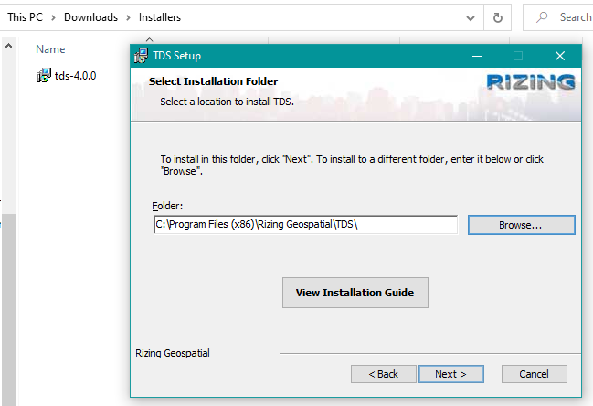
Tip: Clicking View Installation Guide will bring up this topic in the User Guide.
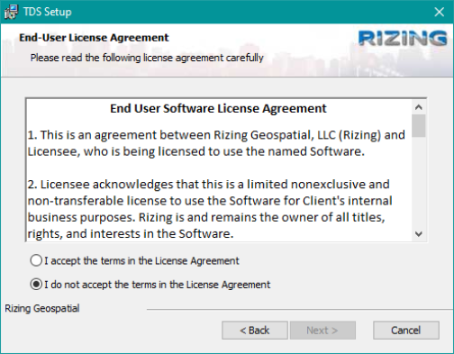
Read and agree to the license agreement then click Next.
Choose your authentication method and rename the IIS (Internet Information Services ) Site, Application and/or Application Pool if desired then click Next. An overview of each option is outlined below.
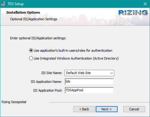
- Selecting Use application's built-in users/roles for authentication will allow you to register and create user roles that will be stored in the applications database.
- Selecting Use Integrated Windows Authenticated (Active Directory) will allow you to use Active Directory users/roles across your applications.
- IIS Site Name: leave default or enter a new name. This is set to Default Web Site ("WEBAPP") by default.
- IIS Application name: leave default or enter a new name. This is set to tds by default.
- IIS application pool: leave default or enter a new pool. This is set to TDSAppPool by default.
Note: Recommended: Leave Launch application after install checked to launch App Manager once installation is complete.
If you'd like the installer to install all other Rizing Geospatial web applications located in the selected installation directory (or sub-directories), select the option to Automatically run other installers in this directory. Otherwise, click Install to run the TDS installation.
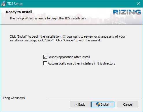
Once you click Install, a series of confirmation prompts will open. Click OK to confirm each prompt.
The application should now load in your default browser window if Launch application after install was left checked.
Repeat steps 1-3 above for each web application installer.
Tip: While this step is not required, it will make the configuration process in App Manager go more smoothly if all of the applications are installed prior to running through the Configuration Wizard.
Tip: This is the quickest and easiest way to get started with App Manager. The Configuration Wizard will walk you through importing your seed data file (if we provided you one) and all the core configuration settings needed to get up and running with all of our web applications.
Further detailed information on the underlying web application framework that App Manager sits on top of, including additional installation guidelines and technical specifications, see the Expanding Knowledge section.
Updating an Existing Installation
Heads Up! Rizing recommends that you install the latest versions of each product as it is released. If support is requested related to a bug that has been fixed, Rizing requires that the software be updated to the most recent version before continued support related to that bug can be provided.
To update the application, simply run the new installer and the previous application version will automatically be updated to the new one. Create a backup of the configuration store database prior to upgrading any software.
When upgrading software in a replicated environment (multiple machines running TDS), the following steps should be taken:
- Make a backup of the TDS configuration store database.
Tip: You can check the Configuration Store to determine where this is stored. If you are using the default (local file database), you will need to go to where TDS was installed and copy the "TDS.sdf" file.
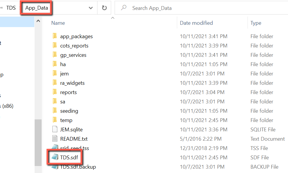
If you specified a database, make a backup of that database. - In IIS Manager, stop the application pool for each replicated instance.
Note: The default TDS app pool is TDSAppPool.
- Install the latest applications (run all installers) on one of the replicated servers.
- Repeat this steps for each of the replicated servers.
- Test each server independently and then test access through the load balancer (once all servers have been brought back online).
- Navigate to Programs and select Uninstall for TDS.

- Click Uninstall on the confirmation popup.

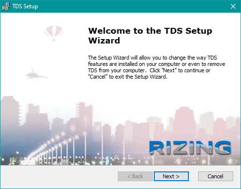
- The TDS Setup Wizard will open. Click Next.
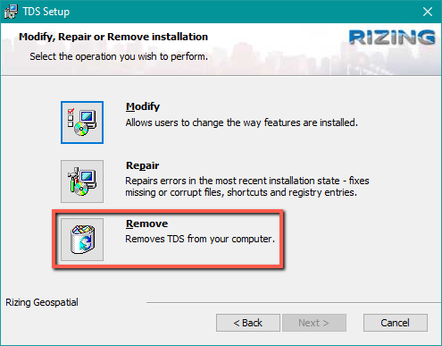
- Select Remove from the list of options then click Next.
- Select the items you wish to remove, then click Remove.
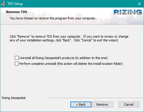
- To uninstall all Rizing Geospatial products, select Uninstall all Rizing Geospatial's products (in addition to this one).
- To automatically remove the TDS folder (including any data or files/folders contained therein) after uninstalling, select Perform complete uninstall (this action will delete the location folder)
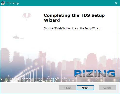
- Click Finish to complete the uninstall.
Note: The application installer will automatically make a copy of the application's web.config and configuration database (if it is using SQL Server Compact) before performing the upgrade. If you are not running a standard configuration, backup your files manually.
Heads Up! Whenever a product installer is run, the application will automatically be taken offline. If you are not running a standard configuration, manually take the application offline. This will ensure it is not accessible to the public which could interfere with the installation process.
Google Maps and Bing Maps API Disclaimer
Google Maps: All Google Maps JavaScript API applications are subject to the limitations of Google's Terms of Service. Therefore to use any imbedded Google Map tools within the applications, you will need to adhere to Google's Terms of Service - this typically means you need to purchase an enterprise license. To learn more please visit Google Maps' Get a Key/Authentication page.
Bing Maps: Using the Bing Maps API in authentication restricted applications may require the purchase of the Bing Maps API License. Please refer to their Bing Maps API licensing options for more information.
